Thursday, December 15, 2022

Final Blog Post

 Main natural hazards

The two most important hazards in the Philippines to address are coastal hazards and mass wasting (landslides). The worst coastal hazard in the Philippines is coastal erosion. As the news has shown, coral reefs all around the world are diminishing quickly. In the Philippines, the coral reefs are facing further diminishment from ocean acidification and other human interaction. Sadly without the coral reefs, the coastline is vulnerable to waves coming in with a stronger force. This is because the fully alive coral reefs before blocked around 97% of the incident wave energy. Now the waves are crashing into the ground that much harder and causing erosion. The coastal erosion leads to major costs in damage and the coastline moving further and further back from so much wear against the sand/rocks. 


Along with coastal hazards, mass wasting has proven itself as one of the most dangerous hazards to the Philippines, specifically landslides. Since the Philippines goes through two monsoon seasons, one from October to March and another from June to October, there is typically very heavy rainfall. This heavy rain is the main cause of the landslides in the Philippines. This is because the soil becomes oversaturated making it loose, and the plants are taking in the water and the vegetation is growing to make the slope heavier. Since the slope is heavy with vegetation it increases the chance of a slide due to its weight. 
I am addressing these as a priority because the Philippines has spent billions of dollars on repairs and is now prioritizing these hazards by planning prevention methods.

My recommendations based on what I have learned on how to mitigate certain hazards is to install shotcrete walls, retaining walls, and seawalls, and to have visible signs in populated or dangerous areas of these hazards. The shotcrete walls are to deals with landslides because they will spray concrete on the side of the slopes and the concrete does not retain any water, therefore it can prevent a full-strength landslide. The retaining walls would be also beneficial to the prevention of landslides because there will be tall structures built by the sides of roads and on the sides of slopes that will hold the soil in place. As for the mitigation of coastal hazards such as erosion, there are seawalls. The seawalls protect the sand/seacliffs from the waves hitting them, therefore preventing further erosion. Lastly, I believe in having signs and education on what to do when you are in an area prone to hazards. By keeping people educated there is further prevention. 

For my mitigation efforts of landslides, I would target central cities such as Manilla because of the many landslides that impact central roads. Because Manilla has a population of 1.78 million, it is necessary to have road access. Manilla is surrounded by areas that could be easily threatened by landslides, due to the tall unstable slopes on the sides of the roads. 
As for mitigation efforts of the coastal erosion, I would target small communities on the coastline such as Basco and El Nido. This is because they face the threat of losing their community from coastal erosion because they are built right on the coast.  As well as being in danger of coastal erosion leading to dangers in the community, many small communities are isolated from access to quick aid. 

I would construct my house in Antipolo, Philippines based on the think hazard map provided by the Philippines. This map highlights the risk of landslides and Antipolo is out of the danger zone. As well as being safer from the danger of landslides Antipolo is away from the coastline therefore there is no risk of living on an eroding coastline. As well as being away from the hazards, Antipolo is not so isolated that if there was a disaster there could be aid considering Manilla is only a little over an hour away. 


References:
https://toolkit.climate.gov/topics/coastal-flood-risk/coastal-erosion#:~:text=Already%2C%20coastal%20erosion%20costs%20roughly,structures%20and%20loss%20of%20land.&text=Coastal%20erosion%20is%20the%20process,or%20sands%20along%20the%20coast.

https://www.nps.gov/subjects/erosion/mass-wasting.htm

https://worldpopulationreview.com/world-cities/manila-population

https://blogs.agu.org/landslideblog/2022/07/28/abra-earthquake-1/

https://en.wikipedia.org/wiki/Basco,_Batanes

https://coastalcare.org/2015/06/boracay-experiencing-beach-erosion-70-coral-loss-philippines/


Thursday, November 17, 2022

Coastal Hazards

 The Philippines is prone to many coastal hazards such as, coastal erosion and tsunamis.

As for coastal erosion, many factors such as large waves, rising sea levels and strong winds can be a factor. But human interaction also has a devastating effect to coastal erosion. For example, the destruction of coral reefs in the Philippines has caused damage in that the reef proved a barrier to weaken the waves and now the waves are much stronger. The protection of coral reefs is very important because 97 percent of incident wave energy can dissipate with coral reefs. 


Tsunamis are also a major hazard in the Philippines. Although the tsunamis in the Philippines are not as big as some of the more famously large tsunamis there destruction is real. The Moro Gulf tsunami of 1976 was one of the worst tsunamis to ever hit the Philippines. The tsunami had around 8,000 casualties, many of these casualties include people who were never found after the tsunami. The tsunami was brought on by a 8.1 magnitude earthquake in an ocean trench. The tsunami lead to mass erosion of the coastline, almost completely eroding older bedrock and moving sediments all the way to the mangroves. As we can see in the map below much of the coastline has experienced severe soil erosion, much of which small tsunamis have contributed


The main way the Philippines are trying to tackle these coastal hazards is seawalls. The seawall is meant to protect the towns near the coast, as well as the beaches from erosion. If the waves cannot reach the coastlines and the seawall protects the sand/sea cliffs, then there is minimal risk for erosion. 

References
https://ideas.repec.org/p/eep/pbrief/pb2009082.html
https://www.worlddata.info/asia/philippines/tsunamis.php#:~:text=A%20total%20of%2021%20tidal,a%20height%20of%20nine%20meters.
https://www.nationalmuseum.gov.ph/2021/11/05/tsunami-in-the-philippines-world-tsunami-awareness-day/
https://www.usgs.gov/centers/pcmsc/science/role-reefs-coastal-protection
https://r11.denr.gov.ph/index.php/rxi-maps
https://zamboanga.com/z/index.php?title=File:Minuhang,_Barugo_Sea_Wall_built_by_local_community.jpg

Monday, October 24, 2022

Extreme Weather

    A common extreme weather event in the Philippines is monsoon rains. There are two types of monsoons in the Philippines : Amihan and Habagat. 

AMIHAN: This is known as the Northeast monsoon and "cool and dry northeast wind coming from Siberia and China and blows down to Southeast Asia". It typically takes place between the months of October to end of March. 

Habagat : This is characterized by the humid weather and heavy rainfall monsoons. It is also known as the Southwest monsoon. The rainfall during this time is more excessive than Amihan and often results in millions of dollars in damage. It typically takes place between the months of end of June to October. 


-Safety tips for monsoon season are:


*When you are meant to evacuate, follow instructions and leave. 

*Repair any damage to your home ahead of time such as the roof.

*Have all medication in a safe place with extras as there way be no way to receive such medications.

*If you are driving and the floods are to difficult to move through, leave your car and find higher ground.

On the 24 of July, 2021 there were reported heavy monsoon rains leading to flooding and the endangerment of people living in Manila. A total of 14,023 had to leave Manila and go to evacuation centers set up for those in need. Luckily there were no casualties and little damage sustained besides high flood waters. 


The monsoon rain storms in the Philippines are only becoming stronger because of the rising ocean temperatures in the Pacific Ocean. As the evaporation becomes more prominent the heat from the Pacific Ocean rises into the air since warm air rises. It cause more tropical and threatening monsoon seasons. 

Resources:

https://www.aljazeera.com/news/2021/7/24/philippines-evacuates-thousands-as-monsoon-rains-flood-cities-pr

https://www.divescotty.com/underwater-blog/amihan-habagat-monsoon.php

https://www.abs-cbn.com/newsroom/listicles/2018/8/30/10-safety-tips-for-the-family-during-the-habagat-s?lang=en

https://www.philstar.com/nation/2022/06/30/2191858/rainy-across-philippines-caloy-enhances-habagat

https://www.edf.org/climate/how-climate-change-makes-hurricanes-more-destructive#:~:text=Warmer%20oceans%20fuel%20storms&text=Evaporation%20intensifies%20as%20temperatures%20rise,when%20the%20storms%20hit%20land.


Monday, October 17, 2022

Mass Wasting In The Philippines


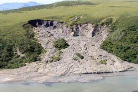
One of the worst landslides in the Philippines occurred on February 17, 2006. The landslide killed 85 people and 981 were confirmed missing. It was said that the heavy rains were the cause of the landslide. The heavy rains caused mass flooding which then caused the landslide on the island of Leyte and Mindanao. 

When the soil became saturated it become loose and made the slope unstable, causing it to slide. 

According to the Philippines Mines and Geoscience Bureau, 80% of the land in the Philippines is prone to landslides. This is due to monsoons, earthquakes, and flooding that occurs often. Earthquakes can cause landslide by the intense shaking loosening the soil and making the ground unstable. 


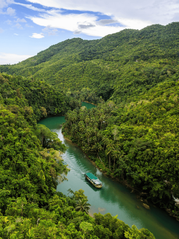
                                                    Because of the mass rainfall in the Philippines there is lots of vegetation and greenery. This vegetation can appear on slope
 and can increase chance mass wasting such as a landslide, mudslide, or rockslide. The plants absorb the water from the rainfall to help grow. The water goes to the roots of the plant and into the soil for more nutrients. But with so much water going into the soil it is loose. Also the weight of the slope is heavier with vegetation and if it is weighted down it can slide. 


The PHIVOLCS department in the Philippines has tried to create a safety system for mass wasting occurrences. 


The top three most effective safety systems in place in my opinion are:

1). Creating retaining walls that look like tall stairs up the sides of roads and land, to hold soil in place. 

2). Shotcrete walls, which are very strong sprayed concrete that should not retain water therefore keeping it safer than the slopes. 

3). Having public safety signs up on main roads, in nature, near farming or large slopes that say there could be a mass wasting event nearby if hit by an earthquake or monsoon rains. As well as signs that clarify if there had been a mass wasting event here before. 

Overall the Philippines has taken many precautions in order to prevent and aid an mass wasting. 


References:

https://earthobservatory.nasa.gov/images/16144/landslide-in-the-philippines

https://www.bria.com.ph/articles/landslide-risk-reduction-schemes-in-the-philippines/#:~:text=According%20to%20the%20Philippine%20government's,Indonesia%2C%20India%2C%20and%20China.

https://pnsn.org/outreach/earthquakehazards/landslides

https://www.utsa.edu/today/2015/09/landslides.html#:~:text=Plants%20absorb%20water%20and%20reduce,die%2C%20resulting%20in%20more%20landslides.

https://www.phivolcs.dost.gov.ph/index.php/landslide/landslide-prepareness

https://en.wikipedia.org/wiki/Shotcrete#:~:text=Shotcrete%2C%20gunite%20(%2F%CB%88%C9%A1,%2C%20steel%20mesh%2C%20or%20fibers.

Sunday, September 25, 2022

Week 5: Volcanoes

 In the Philippines around 400 volcanoes, 25 of which are active. 


Here is a map of 25 active volcanoes and as you can see many of the volcanoes are spread out among different islands. On January 12th, 2020 the volcano, Taal, created hazards such as "volcanic lightning, lava fountains... and fissures that cut through the ground" in specific areas of the Philippines. This was rated a 4 out of 5 hazard level by PHIVOLCS.  

This is only one example of how hazardous volcanoes can be to the Philippines. In many situations, the volcanoes act as a domino effect and cause more disasters such as earthquakes. 


It is also important to note that there is an active underwater volcano named Didicas. Didicas is a submarine volcano first recorded in 1773. Although there are very few cases of death related to the activity from Didicas, it has been recorded. 

The Philippine Institute of Volcanology and Seismology (PHIVOLCS) is in charge of keeping people safe and creating warnings in the event of volcanic activity. 

They are in charge of creating safety plans for people to follow, having a reliable warning system in place, and also monitoring the probability and occurrence of volcanic activity. 

https://www.discoverthephilippines.com/25-active-volcanoes-in-the-philippines/

https://sea.mashable.com/science/7008/the-largest-known-volcano-in-the-world-has-been-discovered-in-the-philippine-sea

https://www.vulkaner.no/v/volcan/mayon/didicas.html

https://temblor.net/earthquake-insights/philippine-volcano-taal-erupts-with-a-fury-of-earthquakes-and-ash-10371/

https://www.phivolcs.dost.gov.ph/index.php/about-us/about-phivolcs


Friday, September 9, 2022

Week 3: Earthquakes


The Philippines has an abundant history of earthquakes but while there have been catastrophic earthquakes, the majority have a magnitude of 4-5. There are on average 982 earthquakes a year in the Philippines, but many cannot be felt. 

According to the Iris monitoring website, the most recent earthquake in the Philippines was on September 4th, 2022 with a magnitude of 4.5. The image below is the waveform from the September 4th earthquake taken by the Global Seismograph Network from Po Shan, Hong Kong.

The P wave formation in the reading tells us that the P waves travel faster and the station can therefore pick up the waves faster. What the reading mostly picked up is the surface waves. It is likely that these surface waves were picked up in the form of ocean waves. The particles of the median in this graph move up and down. When I listened to the waveform graph I could hear the up and down shaking movement, which is verified by the graph. 

Like many earthquakes, scientists can hypothesize that it comes from a fault of some sort. After studies of the faults around the Philippines, it was determined that the fault most related to the earthquakes is the "Central Philippine Fault Zone consisting of the Guinayangan, Masbate, and Central Leyte faults". The Philippine Fault is a strike-slip fault which tells us its movement is horizontal. This type of fault is dangerous because it can cause buildings to fall apart, and roads to break due to shearing stress. 


The Philippines have put together what they call a more "reactive" approach rather than a proactive approach. They do not spend as much time trying to prevent earthquakes as they do dealing with the damage after it happens. This has caused many financial burdens among the citizens and government in the Philippines. 

A few proactive disaster precautions the Philippines has taken is having disaster management centers that provide aid, rescue, and information. As part of this program, they conduct research and help teach people what to do in case of an emergency disaster such as an earthquake. 


References:

https://www.adrc.asia/management/PHL/Philippines_Disaster_Plans.html#:~:text=The%20Philippine%20disaster%20management%20program,information%2C%20and%20research%20and%20development.

https://openknowledge.worldbank.org/handle/10986/8748#:~:text=The%20Philippine%20institutional%20arrangements%20and,avoid%20the%20creation%20of%20disaster

https://www.independent.co.uk/news/world/asia/philippines-earthquake-today-masbate-cataingan-death-toll-a9675236.html

https://www.forbes.com/sites/trevornace/2019/04/22/earthquake-shakes-philippines-leaving-five-dead-north-of-manila/?sh=4aedf82861f1

http://ds.iris.edu/ds/nodes/dmc/tools/event/11594811

https://en.wikipedia.org/wiki/Philippine_Fault_System#:~:text=and%203.8%20Ma.-,Earthquakes,islands%20of%20Bondoc%20to%20Leyte.

https://www.phivolcs.dost.gov.ph/index.php/2-uncategorised/635-philippine-fault-zone-maps#:~:text=The%201%2C200%2Dkm%2Dlong%20Philippine,northwestern%20Luzon%20to%20southeastern%20Mindanao.


Friday, September 2, 2022

Tectonic Plates

Based on the NOAA map of tectonic plates we can see that the Philippines is in close proximity to multiple plate boundaries. These plates are the Philippine Sea Plate, Indo-Australian Plate, and the Eurasian Plate.

The plate tectonic movement near the Philippines is what creates such a high chance for disaster. Since the Philippines is located in the Southeast Asia part of the Pacific Ring of Fire. Where the plates meet and the volcanoes surround the Philippines there is an overlap of convergent boundaries. This overlap of convergent boundaries is called a subduction zone. Specifically significant to the Philippines is the Philippine Sea Plate because it is moving towards the Eurasian Plate at a rate of  "6-8 cm/year". The subduction causes earthquakes, volcanic activity, and more. 

It is interesting as to why the Eurasian Plate is being subducted under the Philippine Sea Plate since it is mostly continental crust. This also explains why there is the philippine fault. If the fault slips it will cause a devastating disaster.


Overall the chance for disaster in the Philippines is very high due to the mass movement of tectonic plates and the convergence of multiple plate boundaries. 

SOURCES:

https://tectonicsofasia.weebly.com/philippine-sea-plate.html

https://agupubs.onlinelibrary.wiley.com/doi/full/10.1002/2016JB012923

https://www.nationsonline.org/oneworld/map/philippines-political-map.htm#:~:text=The%20archipelago%20is%20situated%20within,intense%20volcanic%20and%20seismic%20activities.&text=Along%20the%20eastern%20side%20of,floor%20of%20the%20Philippine%20Sea.

https://agupubs.onlinelibrary.wiley.com/doi/full/10.1002/2016JB012923

Final Blog Post

  Main natural hazards The two most important hazards in the Philippines to address are coastal hazards and mass wasting (landslides). The w...